- Search
- nca3 report
- publications
- contributors
dataset : NSCAT Level 3 Daily Gridded Ocean Surface Wind Vector Browse Images (JPL)
nasa-podaac-nscat_level_3_browse_images
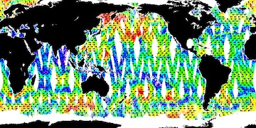
NSCAT Level 3 Daily Gridded Ocean Surface Wind Vector Browse Images (JPL)
This dataset provides browse images of the NASA Scatterometer (NSCAT) Level 3 daily gridded ocean wind vectors, which are provided at 0.5 degree spatial resolution for ascending and descending passes; wind vectors are averaged at points where adjacent passes overlap. This is the most up-to-date version, which designates the final phase of calibration, validation and science data processing, which was completed in November of 1998, on behalf of the JPL NSCAT Project; wind vectors are processed using the NSCAT-2 geophysical model function. Information and access to the Level 3 source data used to generate these browse images may be accessed at: http://podaac.jpl.nasa.gov/dataset/NSCAT%20LEVEL%203.
podaac.jpl.nasa.gov
http://podaac.jpl.nasa.gov/dataset/NSCAT_LEVEL_3_BROWSE_IMAGES
Identified by : NSCAT_LEVEL_3_BROWSE_IMAGES
This dataset was released on November 08, 2012.
The time range for this dataset is September 15, 1996 (03:04 AM) to June 29, 1997 (22:32 PM).
The spatial range for this dataset is -75° to 75° latitude, and 0° to 360° longitude. map (center)
This dataset uses data from an instance of the nasa-scatterometer instrument on the advanced-earth-observing-satellite platform.Also known as :
- dataset NSCAT_LEVEL_3_BROWSE_IMAGES (podaac lexicon)
- datasetId PODAAC-NSJPL-L3I02 (podaac lexicon)
Alternatives : JSON YAML Turtle N-Triples JSON Triples RDF+XML RDF+JSON Graphviz SVG
