- Search
- nca3 report
- publications
- contributors
dataset : ERS-1 Gridded Level 3 Enhanced Resolution Sigma-0 from BYU
nasa-podaac-ers-1_byu_l3_ow_sigma0_enhanced
ERS-1 Gridded Level 3 Enhanced Resolution Sigma-0 from BYU
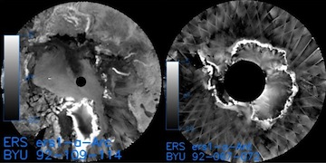
This European Remote Sensing (ERS) Sigma-0 dataset is generated by the Scatterometer Climate Record Pathfinder (SCP) project at Brigham Young University (BYU) and is generated using a Scatterometer Image Reconstruction (SIR) technique developed by Dr. David Long at BYU. The dataset provides SIR processed Sigma-0 data from the ERS-1 C-band scatterometer, which is also known as the Active Microwave Instrument (AMI). AMI is a multimode radar operating at a frequency of 5.3 GHz (C-band), using vertically polarized antennas for both transmission and reception. The SIR technique results in an enhanced resolution image reconstruction and gridded on an equal-area grid (for non-polar regions) at 8.9 km pixel resolution stored in SIR files; polar regions are gridded at the same resolution using a polar-stereographic technique. A non-enhanced version is provided at 44.5 km pixel resolution in a format known as GRD (i.e., gridded) files. All files are produced in IEEE formatted binary. All data files are separated and organized by region, parameter, and sampling technique (i.e., SIR vs. GRD). The regions of China and Japan are combined into a single region. In addition to Sigma-0, various statistical parameters are provided for added guidance, including but not limited to: standard deviation, measurement counts, pixel time, Sigma-0 error, and average incidence angle. This dataset was once distributed on tape, but has been made available on FTP thanks to the BYU SCP.
podaac.jpl.nasa.gov
http://podaac.jpl.nasa.gov/dataset/ERS-1_BYU_L3_OW_SIGMA0_ENHANCED
Identified by : ERS-1_BYU_L3_OW_SIGMA0_ENHANCED
This dataset was released on November 21, 2011.
The time range for this dataset is January 01, 1992 to May 17, 1996 (23:59 PM).
The spatial range for this dataset is -79.7° to 88.2° latitude, and -180° to 180° longitude. map (center)
This dataset uses data from an instance of the active-microwave-instrumentation-image-mode instrument on the european-remote-sensing-satellite-1 platform.Also known as :
- dataset ERS-1_BYU_L3_OW_SIGMA0_ENHANCED (podaac lexicon)
- datasetId PODAAC-ERS1B-SNEN0 (podaac lexicon)
Alternatives : JSON YAML Turtle N-Triples JSON Triples RDF+XML RDF+JSON Graphviz SVG
