- Search
- nca3 report
- publications
- contributors
dataset : GHRSST Level 4 DMI_OI Global Foundation Sea Surface Temperature Analysis (GDS version 2)
nasa-podaac-dmi_oi-dmi-l4-glob-v1-0
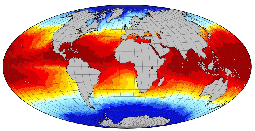
GHRSST Level 4 DMI_OI Global Foundation Sea Surface Temperature Analysis (GDS version 2)
A Group for High Resolution Sea Surface Temperature (GHRSST) Level 4 sea surface temperature analysis produced daily on an operational basis by the Danish Meteorological Institute (DMI) using an optimal interpolation (OI) approach on a global 0.05 degree grid. The analysis is based upon nighttime GHRSST L2P skin and subskin SST observations from several satellites. The sensors include the Advanced Very High Resolution Radiometer (AVHRR), the Spinning Enhanced Visible and Infrared Imager (SEVIRI), the Advanced Microwave Scanning Radiometer 2 (AMSR2), the Visible Infrared Imager Radiometer Suite (VIIRS), and the Moderate Resolution Imaging Spectroradiometer (MODIS) on Aqua. An ice field from the EUMETSAT OSI-SAF is used to mask out areas with ice. This dataset adheres to the version 2 GHRSST Data Processing Specification (GDS).
podaac.jpl.nasa.gov
http://podaac.jpl.nasa.gov/dataset/DMI_OI-DMI-L4-GLOB-v1.0
Identified by : DMI_OI-DMI-L4-GLOB-v1.0
This dataset was released on July 17, 2013.
The time range for this dataset starts at April 30, 2013.
The spatial range for this dataset is -90° to 90° latitude, and -180° to 180° longitude. map (center)
This dataset uses data from an instance of the moderate-resolution-imaging-spectroradiometer instrument on the aqua platform.This dataset uses data from an instance of the advanced-very-high-resolution-radiometer-3 instrument on the meteorological-operational-polar-satellite-a platform.
This dataset uses data from an instance of the moderate-resolution-imaging-spectroradiometer instrument on the terra platform.
This dataset uses data from an instance of the advanced-very-high-resolution-radiometer-3 instrument on the national-oceanic-and-atmospheric-administration-19 platform.
This dataset uses data from an instance of the advanced-microwave-scanning-radiometer-2 instrument on the global-change-observation-mission-w1 platform.
This dataset uses data from an instance of the visible-infrared-imager-radiometer-suite instrument on the suomi-national-polar-orbiting-partnership platform.
Also known as :
- dataset DMI_OI-DMI-L4-GLOB-v1.0 (podaac lexicon)
- datasetId PODAAC-GHGDM-4FD02 (podaac lexicon)
Alternatives : JSON YAML Turtle N-Triples JSON Triples RDF+XML RDF+JSON Graphviz SVG
